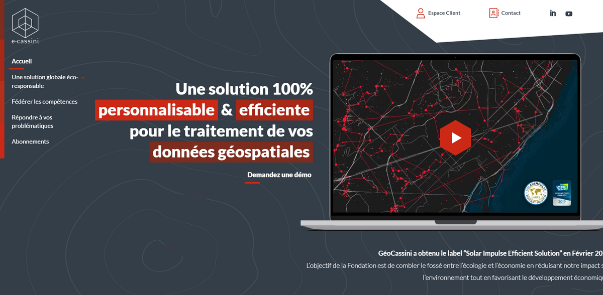
What is the Project?
GéoCassini has obtained the “Solar Impulse Efficient Solution” label in February 2021 – a recognition that sets it apart in the world of geospatial solutions. The objective of the Foundation is to bridge the gap between ecology and economy by reducing our environmental impact while promoting economic development. This 100% web platform, accessible in SaaS mode, is dedicated to the storage, management, exploitation, updating, and exchange of all your data describing space and its contents. In essence, GéoCassini is designed to be the cornerstone for organizations, municipalities, communities of municipalities, and departments looking to centralize and optimize the handling of georeferenced data. It’s impressive how this platform consolidates information and provides a robust tool for managing every nuance of spatial data – sometimes, it really feels like the perfect digital assistant for your GIS needs…
Main Benefit
The benefits of using GéoCassini stretch far beyond its modern design. It not only simplifies complex data processes but also ensures that users can track and securely access important information. Consider these key figures and facts:
- Obtained the “Solar Impulse Efficient Solution” label in February 2021.
- Only 100% web platform available in SaaS mode for geospatial data management.
- Dedicated to data storage, management, exploitation, updating, and exchange.
- Supports various scales – from small projects to entire communities.
- Integrates publication capabilities via GéoStore with traceability elements for connecting with the data owner.
Project Features
GéoCassini is not just a platform—it’s a comprehensive solution that unites ecology and economy in a smart, user-friendly fashion. With its design rooted in bridging environmental impact and economic development, this tool manages all types of georeferenced data, including orthophotos, LIDAR data, SIG layers, and more. The clean, intuitive interface makes it easy for users to navigate the complex fields of GIS while benefiting from a highly robust engine behind the scenes. The inclusion of features such as data storage and efficient updating mechanisms ensures that every piece of information remains current and readily available. There’s a sense of calm efficiency in the way the tool assembles data, offering users both clarity and depth with each interaction…
Data Management Prowess
In today’s fast-paced digital landscape, impeccable data management is crucial. GéoCassini stands out by aggregating all the GIS data and their environment into one accessible platform. It harnesses the potential of modern technology to store, update, and exchange data seamlessly. The platform’s central role in managing geospatial data provides extensive flexibility – perfect for projects ranging from municipal developments to larger community-wide initiatives. By ensuring that every dataset is meticulously handled, GéoCassini delivers a level of operational smoothness that few other tools can match. The systematic approach to managing databases not only speeds up processing times but also minimizes errors, making every transaction feel natural and less like a chore.
Immersive LIDAR Experience
One of the most engaging aspects of GéoCassini is its capability to aggregate data through visualization of all LIDAR data in an immersive view. Employing advanced visualization techniques, the platform provides users with a firsthand look into the landscapes their data represents. Imagine navigating through an interactive digital twin of your environment – that’s what GéoCassini offers. It is “the missing tool” that allows clients to fully integrate the relevance of LIDAR data into their projects, ensuring that every digital park, building, and space is characterized with stunning clarity. The immersive LIDAR experience not only enhances data interpretation but also invites a new level of interactivity and engagement with spatial information…
Project Impact
- SDG 8: Decent Work and Economic Growth
- SDG 9: Industry, Innovation, and Infrastructure
- SDG 11: Sustainable Cities and Communities
- SDG 12: Responsible Consumption and Production
- SDG 13: Climate Action
Future Perspectives
GéoCassini continues to pave the way in geospatial data management with its forward-thinking approach and innovative solutions. As new challenges emerge in the realms of environmental sustainability and digital transformation, the platform stands ready to evolve and expand its offerings. Its adaptability, combined with the robust management of orthophoto and LIDAR data, paints a promising picture of enhanced analytical capabilities and improved user experiences. The commitment to bridging ecological concerns with economic progress not only sets a high standard in the industry but also inspires confidence among users who depend on reliable data for critical decision-making. The journey of GéoCassini is a testament to how merging cutting-edge technology with purposeful design can lead to transformative results – truly a glimpse into a smart, resource-efficient future.