What the Project Is
Vianova serves various organizations for diverse purposes. Intelligence Platform: The operating system of the mobility world. Vianova provides the operating system of the public realm, working with cities and mobility providers to better distribute & control access to public space. The data platform enables seamless exchange of information between mobility providers & cities regarding traffic and curbside management. Cities can get access to mobility insights directly from connected vehicles for improved real-time transport orchestration and more informed urban planning… It is a cutting-edge solution that emphasizes integration and collaboration between cities and connected mobility services.
Main Benefit
Key figures and facts include:
- 120+ CITIES AND BUSINESS CLIENTS
- 280,000+ DATA POINTS PROCESSED DAILY
- 10,000+ TONS OF CO2 SAVED
Data and Professional Services
Data: Real-time and historical data on multimodal transportation flows. Professional Services: Your partner for success. Vianova’s platform offers an innovative approach to manage and optimize the complexities of urban mobility. The platform unifies data, policies, and decisions – all automated and at scale, ensuring that information flows seamlessly between key stakeholders. This integration is crucial in today’s increasingly connected urban landscape, where decision-makers demand rapid access to accurate, real-time data.
Use Cases and Solutions
Solutions By Use Case: Discover how the intelligence platform changed the world for its clients. Use Cases include Data Sharing & Monetisation, Climate Analytics, Logistics & Curbside Management, Multimodal Road Safety, Shared Mobility Management, and IoT Analytics & Infrastructure Management. Industries served include Cities & Governments, Transport Infrastructure, Automotive & Navigation, Insurances, Logistics & Fleets, and Public Transport & Mobility as a Service. Success Stories illustrate how these solutions foster measurable change by improving operational efficiencies and catalyzing smarter urban mobility initiatives.
Technological Implementation
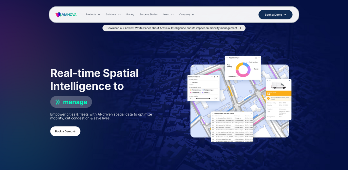
REAL-TIME SPATIAL INTELLIGENCE empowers cities & fleets with AI-driven spatial data to optimize mobility, cut congestion & save lives. Trusted by global leaders in mobility and infrastructure, the platform helps to cut CO2e and optimize transportation at scale. FULL-STACK MOBILITY INTELLIGENCE is at the heart of the solution – smarter mobility starts here as the AI platform unifies data, policies, and decisions in an automated framework. Additionally, SHARED MOBILITY MANAGEMENT helps regulate and manage shared mobility to reduce clutter, improve access, and make cities more livable. Safety & Road Monitoring leverages behavioral analytics and traffic intelligence to identify collision hotspots and enhance roadway safety, while FREIGHT & CURB OPTIMIZATION optimizes loading zones and curbside operations to reduce congestion, improve efficiency, and lower operational costs. Traffic Analytics utilizes real-time transportation analytics to bolster urban mobility, streamline vehicular flow, and reinforce roadway safety. Finally, CLIMATE RESILIENCE aims to reduce transport emissions, build resilient infrastructure, and support sustainable mobility to meet strict climate goals… sometimes the seamless integration feels like poetry in motion.
Project Impact
- SDG 9: Industry, Innovation, and Infrastructure
- SDG 11: Sustainable Cities and Communities
- SDG 13: Climate Action
Future Directions
CREATE YOUR SOLUTION: Design a custom mobility strategy tailored to your city’s needs, solving the most pressing transport challenges. Vianova’s platform not only streamlines operations via its Policy API, which allows mobility providers to dynamically receive geo-fenced regulations such as speed limits, operating zones, curbside restrictions, and road closures from local authorities, but it also redefines how urban spaces interact with shifting mobility paradigms. Mobility providers benefit from receiving regulatory and infrastructural data that helps them adjust operations on-the-fly, while cities gain more control over public space management. This forward-thinking approach ensures that data and physical urban infrastructure continuously evolve together – making transportation smarter, safer, and more resilient in today’s dynamic environment… the future of mobility looks promising with these groundbreaking initiatives.